

“Nibi Chronicles,” a monthly Great Lakes Now feature, is written by Staci Lola Drouillard. A Grand Portage Ojibwe direct descendant, she lives in Grand Marais on Minnesota’s North Shore of Lake Superior. Her nonfiction books “Walking the Old Road: A People’s History of Chippewa City and the Grand Marais Anishinaabe” and “Seven Aunts” were published 2019 and 2022, and the children’s story “A Family Tree” in 2024. “Nibi” is a word for water in Ojibwemowin, and these features explore the intersection of Indigenous history and culture in the modern-day Great Lakes region.
In July of 1800, Alexander Henry needed a new boat. Henry was a Northwest Company partner sent from New Jersey to the heart of fur trade country. His choice of transport was the only vehicle available — canoes, made of birch bark, sewn together with spruce root and sealed with a gum made from pine pitch mixed with ashes and animal fat.
According to Henry’s journal his brigade was carrying “four kegs of gum, bark, and wattap [sic]” while traveling on the Pembina River in Manitoba. And that summer day in 1900 on Basswood Lake, Henry purchased a canoe “for the value of 60 skins, nearly equivalent to the credit given to some Ojibwe for an entire year.”
Building canoes and selling them to European newcomers was just one of the ways Ojibwe families participated actively in a burgeoning capitalistic system, where goods were created and sold on demand. Gum, as well as other products needed for canoe manufacture, made up a large portion of the provisions the Ojibwe supplied to fur company posts, as well as speculators like Henry. The Northwest Company records for June 1797 note that the fort inventory at Grand Portage included “two new canoes as well as 95 rolls of wide birchbark, 1,159 rolls of narrow bark, 3,955 bundles of wattape (split spruce roots), and 5,088 pounds of gum.”
The lakes and rivers along present-day Minnesota border country between Grand Portage and Lake of the Woods, have been navigated for 9,000 years or more by the Dakota, Assiniboine, Cree, and Ojibwe Anishinaabeg. Currently, over 100,000 vacationers each year visit that area via the Boundary Waters Canoe Area Wilderness (BWCAW), established in 1964, allowing only canoe and light motorboat traffic access to one-million acres of fishing and camping grounds. Those who came before, like Canadian fur traders, French Jesuits and early explorers relied heavily on Anishinaabe knowledge of boat building and repair to keep their businesses afloat.
An Industry Held Together with Cultural Knowledge and Pine Pitch
Lee Johnson is the heritage program manager and forest archaeologist for the Superior National Forest, the federal agency that manages the BWCAW. Johnson and team have been scouting locations along the border route for evidence of Ojibwe “canoe factories” where the key component of keeping one’s boat together — pine pitch — was harvested from red pine trees along the travel routes.
Johnson confirms that, according to oral, elder interviews and ethnographic records: white and jack pine trees were also used as a source of gum. However, red pines, if allowed to flourish can often live up to 400 years.
“It seems like red pine were more intensively utilized in the border lakes region,” said Johnson. “It may be a factor of their longevity on the landscape. However, if your canoe was broken and you needed to make expedient repairs, you would likely utilize whatever pitch was handy.”
A team of archaeologists and dendrochronologists (scientists who use the scientific method of dating tree rings) have identified seven stands of red pine with 10 peels or more, plus other smaller clusters of peeled trees along the border route and secondary travel routes. Researchers have mapped out a network of 244 Culturally Modified Trees (CMTs) that help tell the story of early Anishinaabe life on the landscape prior to 1900.
These “Culturally Modified” trees are visually different from other red pines because the harvesters carved out distinctive, oblong peel scars that run along the trunks of the trees — physical evidence of the harvest that most likely occurred during the warm season. Johnson specifies that the red pines in the U.S. Forest Service study are primarily located “near water with southern exposure . . . allowing the sap to flow a little better.”
The orientation of peel scars or “faces” has been linked to ceremonial practices. Sometimes these scars are related to the orientation of the sun, as well as pragmatic reasons related to a certain wood quality or production standard. In an academic article from the University of Minnesota titled “Culturally Modified Red Pine, Birch-Bark Canoes, and the Strategic Geography of the Fur Trade on Lake Saganaga,” the researchers write:
“The predominant north-northeast orientation of peel scar faces in the BWCAW seems likely to reflect practical reasons, as many of the trees were growing on south-southwest facing slopes and the peels were thus created on the uphill side of the tree where footing was more stable. Similarly, the height of most peels was variable but within a reasonable reach for most grown people.”
Trees Tell the Story of the People
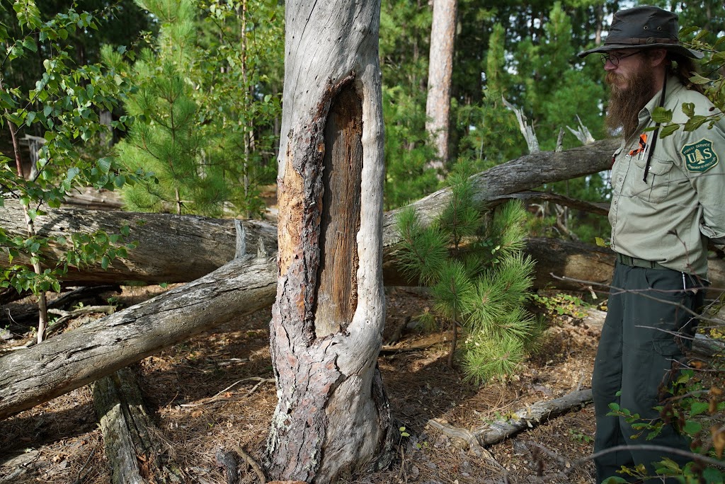
Johnson’s team only collect samples from trees that are dead and downed. (Photos courtesy of the USDA-Superior National Forest and Evan Larson, UW-Platteville)
The dendrochronologists have been able to complete sampling on 141 dead-and-down modified trees, with an earliest peel date of 1743, and the most recent around 1910. Surges in activity occurred in the 1770s and 1790s, correlating with peak use of the border lakes route by the Northwest Company, with a distinct gap in peel activity occurring from 1802 to 1820 when the primary trade route shifted north to the Kaministiquia River. Unfortunately, many red pines located near known peel stands have been lost to fire, particularly a 2007 wildfire on Saganaga Lake that burned a number of historic sites.
These trees help to tie the history of the land to the historic realities of Indigenous people and the various treaties and government acts that greatly impacted the traditional homelands of the border country Ojibwe Anishinaabeg. The Superior National Forest was created in 1909, with the U.S. portion of the border lakes region set aside as a “roadless area,” in 1926.
After that date, development was limited to rustic resorts and summer homes, which explains why the practice of peeling trees in that area essentially stopped after 1910. The Ojibwe families who had lived in the area for hundreds of years, who shared their knowledge and skills in the fur trade through the early years of European exploration, were forced to move.
A 2016 study confirmed that Ojibwe use of Saganaga Lake diminished after 1910. But as Johnson asserts, “many Ojibwe in northern Minnesota continue to exercise treaty rights by harvesting moose, fish, wild rice, and other traditional forest products . . . there is an incorrect assumption that Anishinaabeg land use in the wider 1854 ceded territory contracted following the establishment of reservations, which it absolutely did not.”
He believes that the existence of these red pine stands pushes back on historical narratives about the Ojibwe Anishinaabeg as passive recipients in the fur trade economy. And that the strategic location of peeled tree stands, along with historical accounts of Ojibwe canoe building “factories,” and what traders sometimes referred to as “troublesome” villages that pressed passing travelers for fair trade terms, speaks to the resilience and economic acumen of border lakes Ojibwe Anishinaabeg, who controlled both the labor and products related to canoe building and repair between fur posts.
Retaining access to high-quality forest medicines, like red pine pitch, and the associated benefit of knowing how to build sturdy canoes, contributed to the economics of the time. This also impacted the family and cultural survival, when Ojibwe Anishinaabe people were subjected to land dispossession and forced assimilation on an epic scale. One of the peel stands surveyed by Johnson’s team is located along the Little Sioux River, which was historically (1880-1930) utilized as a canoe route connecting the Lake Vermilion and Lac LaCroix Anishinaabeg communities at Seine River and Neguaguon Lake.
“The peel dates in that stand correspond with oral history accounts of folks from Lac LaCroix using that route to visit family members and kids in Vermilion Residential School,” said Johnson.
When asked why harvesting pitch over a period of many years didn’t kill the trees, Johnson explained that: “the peels did not girdle the entire circumference of the tree. They were made on one face, and typically don’t extend to over 1/3 the circumference of the tree.” The researchers discovered that the tree creates a healing lobe around the scar over time, a symbol of survival — for trees and for the people of the Border Country.
Catch more news at Great Lakes Now:
Nibi Chronicles: Krishna’s quest for ticks
Nibi Chronicles: The Return of Nenookaasiwag
Featured image: Gathering samples from a downed peeled tree for dating. (Photos courtesy of the USDA-Superior National Forest and Evan Larson, UW-Platteville)

