Great Lakes Moment is a monthly column written by Great Lakes Now Contributor John Hartig. Publishing the author’s views and assertions does not represent endorsement by Great Lakes Now or Detroit Public Television.
There are many similarities between Toronto’s lower Don River and metropolitan Detroit’s Rouge River. Both were working rivers that supported industry and commerce, both were polluted waterways that were designated pollution hotspots or Great Lakes Areas of Concern by the International Joint Commission, and both are infamous for catching on fire.
However, the lower Don River is currently going through an ecological makeover that could help inform what could be done for metropolitan Detroit’s lower Rouge River.
Don River in Toronto
The Don River is located in the heart of the Toronto metropolitan area. It is a 24-mile river that stretches from its headwaters on the Oak Ridges Moraine to the Keating Channel where it empties into Lake Ontario. As the city region grew and became more urbanized in order to provide for its expanding population, environmental pollution increased, with no better example than the Don River.
The mouth of the river once had one of the largest marshes in all of Lake Ontario. Over time the Don River was straightened for convenience, channelized, paved and built over, and polluted with all kinds of municipal and industrial waste and land runoff to the point that it twice caught on fire. Heavy oil pollution was the cause of a river fire in 1931 that destroyed a bridge crossing the river at Keating Street. In 1943, severe oil pollution was the cause of a river fire fronting the British American Oil Company’s property.
To no one’s surprise, on July 30, 1958, the Toronto Globe and Mail editorialized that the Don has “waters heavily polluted and laden with scum, its banks littered with all varieties of filth, and the whole sending up foul odors.”
The pollution of the Don – as it is called locally – was one of the primary reasons that the International Joint Commission designated the Toronto and Region a Great Lakes Area of Concern. Few people thought that the Don could ever be brought back to life.
But after years of planning, the federal, provincial, and municipal governments announced in 2017 a $1.25 billion CAN project to bring back the Don and restore the east waterfront.
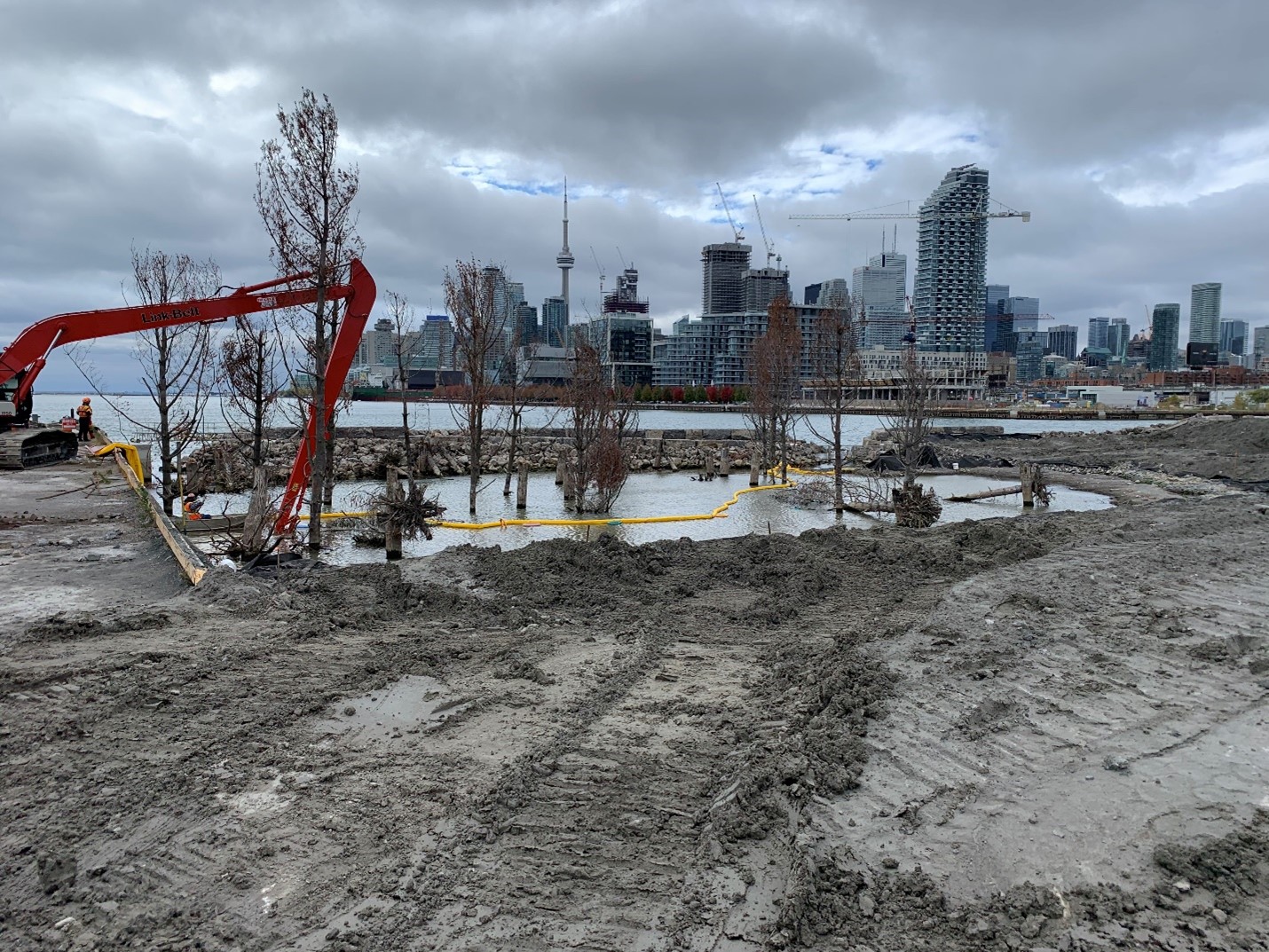
The Don Mouth Naturalization and Port Lands Flood Protection Project is constructing a new naturalized river mouth through the Port Lands, creating a new urban island neighborhood called Villiers Island.
It must be remembered that much of this area along Lower Don River was filled during the 1800s, and as a result many of the historical ecosystem services or benefits were lost, including buffering against flooding, providing habitats for fish and wildlife, filtering stormwater, protecting shorelines from erosion, and supporting recreation. This project will literally transform the existing mouth of the Don River, including the Keating Channel, into a healthier, more naturalized river outlet, while simultaneously providing critical flood protection to 593 acres of Toronto’s eastern waterfront.
The river valley will also add 40 acres of new parkland, promenades and riverfront open space. It will create 36 acres of new aquatic habitat and wetlands to improve biodiversity and water quality and naturally moderate the effects of flooding and erosion. It is also addressing legacy pollution through remediating contaminated soils and sediments through a combination of removal of some contaminated sediments, capping others, and bioremediation – using microorganisms to degrade organic contaminants and make some less toxic. In addition to these environmental benefits, construction will generate approximately $1.1 billion CAD in value to the Canadian economy, 10,829 person-years of employment, and $373 million CAD in tax revenues to all levels of government.
Considerable progress has been made in naturalizing the lower Don River, including sculpting a new river mouth. New parks and trails are being created as part of place making for both wildlife and people.
It is a strategic move to help reconnect people with the Don River and help make nature part of everyday urban life. It has already won many awards, including the Best Overall Project at the 2021 Canadian Brownfield Network Brownie Awards.
The project is projected to be completed in 2024.
Rouge River in Metro Detroit
The Rouge River flows 126 miles through the most densely populated and urbanized area of metropolitan Detroit. Like most urban rivers, the Rouge River has experienced more than a century of human use and abuse. Heavy industry dominates the lower end of the river near its confluence with the Detroit River, resulting in contaminated sediments that are stifling further improvement in the health of the river. Indeed, the lower end of the river was so polluted with oil and other petroleum products, that it even caught on fire on October 9, 1969.
The mid 1980s were a tipping point resulting from:
1) a man’s death from leptospirosis caused by exposure to polluted water from the Rouge River; and
2) the decomposition of so much raw sewage in the lower river that it resulted in the depletion of oxygen in the river that allowed for the production of hydrogen sulfide (the smell of rotten eggs) that caused extensive odor problems in Dearborn and Melvindale.
The severity and extent of pollution became a watershed moment. All 48 communities and county, state, and federal governments came together to develop a remedial action plan to restore all impaired uses. In 1993, Reps. Dingell and Knollenberg brought in $350 million in federal funding to address combined sewer overflows, stormwater pollution and more. More than 380 projects were completed at a cost of over $1.1 billion since 1988, resulting in improved water and biological quality.
But more work on stormwater and green infrastructure is needed.
Laying in the lower river as a relic of the 1960s is a 4-mile-long concrete channel, and there is a need for remediation all contaminated sediments in the lower end of the river. Fortunately, there is the federal Great Lakes Restoration Initiative that has provided $3.8 billion to accelerate cleanup of the Great Lakes since it was established in 2010.
In fiscal year 2022, $348 million was provided to this initiative. In addition, the bipartisan Infrastructure Investment and Jobs Act has provided $1 billion for Great Lakes restoration, with the bulk of this investment going to accelerate cleanup of Great Lakes Areas of Concern by 2030. Through these funding initiatives the remediation of contaminated sediments in the Rouge River is a priority.
Further, the Rouge River Gateway Master Plan is a more than 20-year initiative to reclaim the lower 8-mile stretch of the river as a greenway and water trail and help enhance the ecology and quality of life in communities connected by this corridor. This plan is guided by the Rouge River Gateway Partnership, established in 1999, and made up of key government, business and academic stakeholders along the corridor.
Under development is the Lower Rouge River Water Trail and already completed are some segments of the Rouge Gateway Trail, the restoration of an oxbow at The Henry Ford Museum and Greenfield Village in Dearborn, and the Fort Street Bridge Interpretive Park in Southwest Detroit that improves access to the river, celebrates history and offers a kayak launch.
What can the lower Rouge River learn from the Don River naturalization project?
There are many similarities between these two urban rivers, and some of the lessons learned from naturalization of the Don River could help inform what could be done for our Rouge River. Presented below are two takeaways.
Integrated Solutions:
In terms of what southeast Michigan’s Rouge River can learn from our Don River naturalization project, there was a process in place to bring all levels of government and other stakeholders together to focus on integrated solutions that addressed all the problems at the mouth of the river.
“All key stakeholders were at the table from the beginning to scope out what needed to be done and ensure that there were no unintended consequences,” said Don Ford, senior manager of hydrogeology and source water protection at Toronto Region Conservation Authority.
The environmental assessment took 10 years.
“Not only did the project lay out, early on, the environmental benefits, but it estimated economic benefits, including that construction would generate $1.1 billion CAD in value to the Canadian economy and that the project would unlock $4-5 billion CAD of potential new development on land that would otherwise be undevelopable,” said Ford.
Bold Vision:
The Lower Don naturalization project was a game-changer, not just because of the scope of the effort, but because of the way it changed the way we think about the restoration of Great Lakes waterways.
“A decade ago, the Lower Don project reimagined a hardened urban river outlet as a complex of waterways that blended urban infrastructure with a naturalized river mouth with restored hydrologic and ecological functions,” said Dr. Tim Dekker, president of the environmental and water resources engineering firm LimnoTech in Ann Arbor. He has worked on both the Don and Rouge rivers.
“It was a bold vision that thought about everything at once: remediation, restoration, revitalization, community integration, and economic benefit,” Dekker continued. “The vision was so compelling that everyone felt an urgency to get all the hard upfront work done quickly – addressing contaminant issues and solving the flooding problems that had previously seemed too big to take on. Now construction is well underway and the lesson for other Great Lakes river mouths is clear – casting a vision for the highest and best use of the waterway early sets a context for the hard work of remedy and restoration.”
The Rouge River has made enormous progress in the last 30 years, and work is currently underway to build on that progress. To really move ahead, we all need to envision what we want the Lower Rouge River to be.
The Rouge River Gateway Master Plan was developed more than 20 years ago under the leadership of the University of Michigan-Dearborn’s Vice Chancellor Ed Begale. Today, Dr. Paul Draus of the University of Michigan-Dearborn has picked up the leadership baton for this master plan.
“We need to think big and embrace a grand vision for the Lower Rouge River that is supported by all stakeholders and that includes the entire corridor from the four-mile concrete channel to the Old Channel at Zug Island,” said Draus. The template for this expansive vision already exists in the Rouge River Gateway Master Plan, although it may need updating.
“We have a unique opportunity to transform this waterway into a 21st century model of sustainable redevelopment, where contaminated sediments are remediated, habitats restored, stormwater properly managed, green industry flourishes, people are reconnected to the Lower Rouge through greenways, kayak launches, and water taxis, and the rich history and culture are interpreted and celebrated,” Draus continued. “If transformation can be achieved in blighted urban-industrial rivers like the Don River in Toronto and the Ruhr River in Germany, it surely can be done in metropolitan Detroit.”
John Hartig is a board member at the Detroit Riverfront Conservancy. He serves as a Visiting Scholar at the University of Windsor’s Great Lakes Institute for Environmental Research and has written numerous books and publications on the environment and the Great Lakes. Hartig also helped create the Detroit River International Wildlife Refuge, where he worked for 14 years as the refuge manager.
Catch more news at Great Lakes Now:
River otters return to the Detroit River
Great Lakes Moment: Detroit River, a magnet for bald eagle photography
Featured image: Restoration of the Don River mouth on Toronto’s eastern waterfront (Photo Credit: Don Ford, Toronto and Region Conservation Authority)


